| |
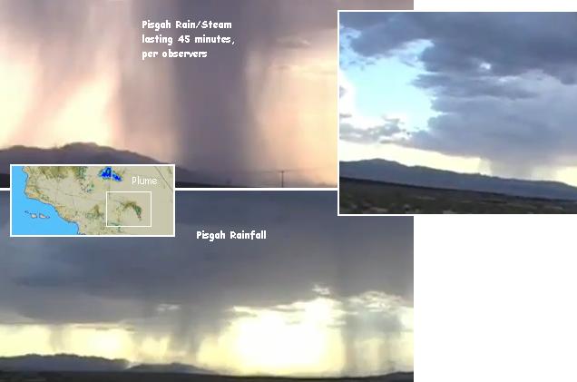
The spout/plume thing stays in one location for at least 45 min. It was definitely raining in those spots. We drove through it. The weird thing was those spots stayed in the same location for 45 min to an hour without moving. http://www.youtube.com/watch?v=J2RBQiDlD_k
Is something other than rain causing what appears to be a plume on weather satellite images, over the Pisgah volcano? Trips to the region by more than one curious
observer have shown that no ash seems to be emerging from the group, no obvious steam vents, and the USGS has even issued a denial. This volcano is in the
inactive region we have stated should be watched for activity, during the New Madrid adjustment. Unlikely to erupt then or during the pole shift, but having
potential to do so. Why was there clearly a plume over this volcano, though only composed of water vapor. It had the appearance of something new in the vicinity
on the satellite image, a new cloud formation, though nothing to generate such a cloud was in the vicinity. It also arose from a pinpoint area, not the general area, as
though something on the ground were the source.
Was this some kind of interaction between the heat in the ground and the water laden air above, causing the appearance of a volcanic plume? Hot spots, hot
springs, geysers, all have their basis in lava near the surface, and even though the Mojave Desert is very dry, there are water sources below ground that vent
upward through the fractures in the ground always present when past volcanic activity has laced mazes through the rock. Yes, the plume came from the ground, but
is nothing more than harmless water vapor.
USGS Rules Out Volcanic Origin of Plume Feature NEXRAD Mojave Desert http://volcanoes.usgs.gov/lvo/ USGS rules out volcanic origin of plume-like feature seen in NEXRAD in Mojave Desert (California). Inquiries have come to the USGS regarding a potential eruption in the vicinity of Lavic Lake Volcanic Field (LLVF) in Southern California. The inquiries stem from a citizen report noting a plume-like feature on NEXRAD radar imagery from July 23, 2011. USGS volcanologists evaluating the situation find nothing to indicate that the NEXRAD feature results from volcanic activity. Satellite images from the same period do not show the steam or ash clouds that accompany volcanic activity, and there is no seismicity in the vicinity indicative of volcanic unrest/eruption. No earthquakes were located within 20 miles of LLVF during the last week (USGS-Caltech Seismic Net update 14:10 PDT July 27, 2011 ). No reports of eruptive activity have come in from ground observers (LLVF is within 2 miles of Interstate 40) or from regional pilots (Barstow Daggett County Airport is within 10 miles of LLVF). http://en.wikipedia.org/wiki/Pisgah_Crater
Pisgah Volcano is the youngest vent, of four cinder cones, in the Lavic Lake volcanic field. There may have been activity at this site as recent as 2,000 years ago, though more likely 20,000 to 50,000 years ago.ZetaTalk Analysis 7/16/2011:
In southern California the Amboy and Salton volcanoes appear relatively inactive, with 10,000 and 14,000 years respectively since last activity per the USGS. But note their close proximity to many fault lines and the San Andreas itself. Though the San Andreas is considered a slip-slide fault, devastating only on the fault line itself, the New Madrid adjustment will do more than move the land up or down along the San Andreas. It will create pressure in the region jumping west during the diagonal adjustment, and this includes all lands to the south of Mammoth Lake. Thus Amboy and Salton should be watched, during the New Madrid adjustment, with evacuation of the immediate area upon any signs of activity.